Dylan's Weather blog Is Moving!
Ok now we arent moving far..I just wanted the blog to be on our sever....Ok so now here is the new forecast blog link....its www.dylansweather.com/blog

Ok now we arent moving far..I just wanted the blog to be on our sever....Ok so now here is the new forecast blog link....its www.dylansweather.com/blog
So We didn't see as much ice as we could have..At the last moment the temps dropped another 2 degrees which saved a lot of people from being hit with quite a bit of ice.
Now there is still a few warning in effect until later this evening as show by the picture below. The storm that dumped 6" (locally more) of snow in spots since last night will continue to exit the eastern Great Lakes. Some areas did not see a whole lot of snow (far Eastern U.P. and NE/E Lower Michigan).
Some total snow reports as of early p.m.:
Curtis in Mackinac Co: 9.0"
Meauwataka in Wexford Co: 7.5"
Cadillac 6.0"
Dighton (9&10 News) 6.0"
Frankfort 6.0"
Newberry 6.0"
Good Hart 5.0"
Paradise 4.0"
Sault Ste Marie 3.0"
Scottville 3.0"
2nd SSM Report 1.0"
(email us weather@9and10news.com or drodenbaugh@hotmail.com )
Behind this system, we will still see some snowshowers (mixed with rainshowers and sleet at times). There will be a few heavier snow bursts before we start to completely quiet down later tonight into Monday morning.Some sunshine returns for Monday. Highs will be in the upper 30's north and into the 40's south. So a much brighter day, for sure!
Rainshowers are looking more and more likely for later Tuesday with a chance for a few rain/snowshowers on Wednesday.Another storm system needs to be watched for later Thursday into Friday.
Snow is possible (or a mix) with this system overnight.While we will see a break from storminess for late Friday into Saturday, yet another system could hit us for Sunday and early next week.
-Meteorologist Jim Lehocky
Officially Its Spring...but the weather isn't showing a hint that its spring.. We are forecasting 5-10 Inches of snow with possibly a .10" hundreds of ice.. Now of coarse my hero Jim Lehocky has been all over this and is explaining what this storm is doing in detail..
**Numerous Winter Weather Alerts**
The storm continues to be on track for tonight and Sunday.
*Winter Storm Warnings and Advisories have been posted for parts of the viewing area*
The computer models continue to be in general agreement on path of storm with the heaviest snow in W/NW Michigan to the Tip of the Mitt to the Eastern U.P. Check out the regional radar loop here to see where the heaviest snow is falling with this system..and the movement.
The storm will move on through Jackson Michigan around daybreak Sunday.This puts all of the viewing area in the cold part of this storm. However, just a few thousand feet above the surface, we will see some warmer air move in from the SE and station itself south of a line from Rogers City to Howard City.
This will complicate the forecast even more because we have a chance for see some mix of snow, freezing rain, sleet and very cold rain which will hamper snow amounts, but will make travel very difficult nonetheless. Areas near Big Rapids, Mt. Pleasant, Gladwin and Midland could see mostly a cold rain tonight.
Remember, a temp drop of a degree or two could mean a freezing rain/mix event.So, again, later tonight and early Sunday, south of a Rogers City-Howard City line, we have that chance for sloppy and slick mix. North of that line, including into the U.P., it should be mainly a snow event.And that leads us to snow totals.
We have to take into account A LOT of factors here for snow totals. This storm is coming through late tonight and early Sunday. Temperatures will be cold enough to support heavy snow in NW/W Lower Michigan and the E. U.P. But we have seen the ground warm up during the daytime hours the past few weeks and that could and will limit some higher amounts.
Also, *any change of path of this storm and any change in the upper level temperature profiles will change where the heavy snow falls compared to the slick and sloppy mix.Ok. In terms of total snowfall for late tonight through Sunday.....
I believe the heaviest snow (5"-10"+) will fall from Oceana/Newaygo Counties NE to Cheboygan County also into Chippewa and Mackinac Counties in the E.U.P. This includes all of NW Lower Michigan in this particular area. Now, with that forecasted mix south of that Rogers City-Howard City line, amounts should be less.
The winds will be brisk tonight and Sunday adding to the misery of the storm. Winds will be NE overnight 12-22mph and gusty. On Sunday, the winds will shift more to the N/NW 15-25mph and gusty.
The bulk of the storm will exit the region (from SW to NE) late in the day Sunday, but the wrap around moisture will give us more snow (and rain/snow mix) through the afternoon hours with some additional, sloppy accumulations in the U.P. and NE Lower Michigan.
-Jim Lehocky, Meteorologist
The skies over Northern Michigan have been clearing nicely this afternoon, the exception is in the U.P. where the clouds are staying thick. A weak cold front coming through tonight will deliver some colder temperatures. Overnight lows of 23 to 32 are expected. You will see more clouds North of M-72 tomorrow as the colder air sits overhead.
Further south, you will see more sunshine and thus warmer temperatures. The U.P. and spots in the thick clouds will see highs in the 30's. Those of you south of M-55 be ready for warmer temperatures with highs in the 40's to near 50 in Mt. Pleasant. North of the straits the cold air will be thick enough to set off a few flurries or snow showers. Our eyes are still focused on a big weekend storm. Saturday starts off quiet but by the afternoon you'll notice a change coming. Winds will be picking up and the clouds rolling in.
Rain is expected to move in and then mix or change over to snow Saturday night. This storm looks to be a messy one, so be prepared for almost anything. Sunday's winds stay very strong blowing the rain and snow around. As colder air moves in any mix will turn over to snow by the afternoon hours. Monday's weather is only a short break before another storm heads into Northern Michigan on Tuesday. This one also looks to bring in a messy mix of rain/ snow and strong winds.
Stay tuned for details.
Dylan Rodenbaugh
Junior Meteorologist
www.dylansweather.com
Strong high pressure to our east and a pretty strong area of low pressure to our west will provide us with a windy period through Tuesday evening. Winds will be E/SE 12-22mph and gusty.
Then the system moves through Wednesday a.m. with winds shifting to the west.These cool, dry winds will eat away at most of the rain that tries to make it into the region today-Tuesday. But eventually the rain will win.
The best chance for rain will be later Tuesday into Wednesday a.m.*The strong E/SE winds and very low relative humidities will create an elevated fire danger this afternoon and evening. Fires can easily spread in conditions at this time of year because vegitation is still dormant and dried out.
Highs today will be in the middle to upper 30's north to the 40' south. Lows tonight will be in the middle 20's and lower 30's. There is a chance for some sprinkles near Lake Michigan in Oceana and Mason counties today But, again, with those winds eating away at the moisture, we expect most areas to be dry with mid to high level cloudiness.
Highs on Tuesday will be a few degrees warmer as the chance for rain increases later on especially into the late evening and nighttime hours.Showers and thundershowers are likely Wednesday a.m. then tapering off to scattered showers and drizzle into the p.m.
Thursday is looking dry but the shower chance once again enters the picture for later Friday into the weekend. It will also be windy Friday-Sunday.
-Meteorologist Jim Lehocky


Although we are much cooler than yesterday, we are still looking at high temperatures today above the normals (38 north to 43 south).
The mercury will rise up into the 40's north and into the 50's south.In terms of sky cover, we are looking at a mix of sun and clouds with a slight chance for a shower or two in the far north by evening as a secondary cold front approaches out of Canada.
This same cold front will usher in cooler (ok...colder) air for later tonight and Thursday. We might be able to squeak out a few lake snowshowers as the winds shift out of the NW. Lows tonight will be in the teens and lower to middle 20's.
Highs on Thursday will be around 30 in the north and upper 30's in the south.
Spring officially starts Friday at 7:44a.m. It is basically going to be a "normal" Spring Day with some sunshine and temperatures where they should be...into the middle 30's north and lower 40's south.
Saturday is looking dry although we will see a mix of sun and clouds. Highs will be in the upper 30's to middle 40's south.
The chance for rain increases later Sunday into early next week.
-Meteorologist Jim Lehocky
Plain and simple. We have been pretty spoiled the past three days (including today) with the sunshine and progressively mild temperatures.
The mercury was able to reach up into the middle 40's to lower 50's north (coolest near Lake Michigan and Superior) and into the middle 50's and some lower 60's south.Tonight, clear skies are likely with some patchy haze.
Lows will be in the 20's and lower/middle 30's.A cold front will move on through the region late Tuesday evening/early Wednesday morning giving us a chance for a few showers at that time. There is a slight chance for a thundershower or two. But before that happens, we will see some very mild temperatures.
Even as the clouds increase, the mercury will jump up dramatically. Highs in the U.P. will be in the 50's. Across much of the L.P. we will see highs in the 60's. There is a chance for a few lower 70's especially in the southern areas.
Of course, we will see the coolest temperatures near Lake Michigan.After a chance for some early morning showers on Wednesday, skies will be variably cloudy. It will be cooler but still rather pleasant with highs in the 40's and some lower 50's.Thursday (the last day of Winter!) is looking partly to mostly sunny with a few light lake snowshowers off of Lake Superior and Lake Michigan.
Highs will be in the middle 30's to lower 40's.Spring starts Friday at 7:44a.m. and we are looking at a mostly sunny day with clouds increasing late in the north.
The weekend is looking somewhat unsettled. We are going to have to keep an eye on the rain and storm threat
Stay Tuned
Dylan Rodenbaugh
Junior Meteorologist
http://www.dylansweather.com/
Today will be partly cloudy with highs in the lower 40's north to middle to upper 40's south. Some areas with no, or little, snowcover will possibly get to around 50!
Monday is looking dry with partly cloudy skies. Highs will be in the middle 40's north to lower 50s' south.A cold front will move through
Tuesday afternoon. It will give us a chance for some showers. But it will be mild with highs in the middle to upper 40's north and in the 50's south.
It will be cooler on Wednesday with a chance for a scattered rain/snow mix. Highs will be in the middle to upper 30's north to the lower/middle 40's south.
Thursday is looking partly cloudy with highs in middle 30's to lower 40's. We could see a snowshower or two later on.
Friday will be a bit cooler than normal (Spring starts at 7:44a.m. Friday!) with highs in the 30's and a chance for a few snowshowers.
Now here is one more big piece news. I am going to Florida with my school for 5 days! Now yes we have to drive down there which could could be interesting... But i am thinking i will like the Nice Hot Weather!! So i think this will be my last post until Next week and then a week after Florida we it will be on spring break so it could not work better. So i will have pictures and updates after i get back. But i checked the forecast and it looks like we will have lower 80's for the entire time and only one day with a chance of t-storms but that is only a 30% chance..
So talk to you next week..I'm going to Florida!!!
Dylan Rodenbaugh
Junior Meteorologist
www.dylansweather.com
We are keeping an eye on a storm system that will zip on through the region tonight and early Wednesday.
Ahead of it for the rest of today, we are still looking at a mix of sleet, snow and rain in the north and plain ol' rain south of M-72/M-55.
Highs today will be in the middle 30's north to the lower/middle 40's south. Winds will be out of the E/SE 8-18 mph heading into the evening hours.
Tonight is going to be quite interesting. The low will track on through the central U.P. On the west side of the low (the western 1/4 of the U.P. and NW Wisconsin) could see blizzard conditions later tonight and Wednesday.The cold front will swing on through the region around midnight (+/- a couple hours either way).
Ahead of it, we will see rain and a chance for thunderstorms. Behind it, the winds will howl as cold air slams into the region.Temperatures this evening (up to the front passage) will be in the 30's and 40's.Temperatures around 8a.m. Wednesday will be in the upper teens west to the middle/uppper 20's east near Lake Huron.
Whatever liquid we have remaining on the roads in the early morning hours could very well "rapid freeze" especially around and just after daybreak.The winds will be a big concern once the cold front passes through the region after midnight. Ahead of it, winds will be out of the SE 10-20mph, but behind it, they will shift from the West 20-40mph and gusty.
*High Wind Watches and Advisories are posted for the region*These strong winds will continue into Wednesday p.m. but shift more to the NW. Lake effect snowshowers are likely...but with the strong winds and plenty of ice cover on the Great Lakes, snow amounts will be held in check. Things quite down for Thursday, Friday and Saturday. On Sunday, though, we could see yet another storm.
Keep it tuned to 9&10 Weather and Dylan's Weather for the latest in forecast updates!
-Meteorologist Jim Lehocky

A storm system will be taking aim on the region for Saturday and Sunday.It appears that this will be a "warm" system giving us mostly a rain (and thunder) threat. There is, however, a chance for an occasional mix in the U.P. and Straits area for Saturday as temperatures here will only reach into the middle to upper 30's. Farther south, we are looking at temperatures mostly in the 40's....hence a rain event is looking likely for both days. Dense fog is also expected Saturday night with the warmer air overrunning the snow pack that still exists in many areas (mostly north of US-10).While the weekend in general is looking gloomy, Sunday will be the day we will have to monitor flooding potential especially in our central counties. There is also a chance for thunderstorms that will enhance the heavy rain threat. Highs on Sunday will be similar to Saturday's highs.In the near term....for tonight, we are looking at partly cloud skies early then increasing clouds later on. Lows will be in the teens and lower 20's.With considerable cloudiness Thursday along with a chance for some light drizzle/rain in the L.P. and some very light mix in the U.P., highs will be in the middle 30's north to lower/middle 40's south.On Friday, skies will clear up a bit allowing some sunshine through. Highs will be in the lower 40's north and upper 40's to lower 50's south.Then getting ready for that unsettled weekend!
-Meteorologist Jim Lehocky....
Now also i want to add in that we are going to see 3 systems to come together to bring possibly a MONSTER storm. Now there could be a huge problem. We could either see rain, or ICE... If we see the ice. The storm system would be called an official ice storm.
I will have a better update tomorrow...its getting late...
Dylan Rodenbaugh
Junior Meteorologist
www.dylansweather.com
Ok first of all i want to tell everybody the weather before we get to far into the website design. The weather for the rest of the week is going to basically going to be warm. We are going to see some clouds but really i do not think anyone is going to argue with 40's for temps!!!!
Also i just want to tell you. The NWS came out with an official snow fall report so far this winter. Cadillac has had 215" so far this year. That breaks the all time record!!! WOW
Ok now i want to say sorry that the website content wasn't updated for 3 days. We have had Internet problems and those i really cant control.
Ok now i also want to tell everyone this. I am going to stop all major improvements to the website until after June 13th, I know that i will make small minor changes to the site. But i have some really amazing plans for the site. I want to put a live weather ticker on the website. I also want to start a twitter account so we can have live weather updates. Now on more really huge change that i want tot make is moving the blog. I am very limited to what i can do with the blog. So i think i am going to move the blog on my sever...Now its going to be a big pain in the neck at first. That's why i am not going ahead with any monstrous changes until after school is done.
Stay tuned to Dylan's Weather.com It will be really interesting. Cant Wait for severe storms!!!
Talk To You Soon
Dylan Rodenbaugh
Junior Meteorologist
Some snow totals emailed and called in to the Weather Center:
Raber 8"
Cedarville 8"
Topinabee 8"
Rogers City 7"
Paradise 7"
Cheboygan 7"
Grace Harbor 7"
Cross Village 6"
Wolverine 5"
Tower 5"
Suttons Bay 3"
Mancelona 2"
Some overnight rainfall amounts:
Newaygo 1.80"
Fremont 1.63"
Mt. Pleasant 1.52"
Saginaw 1.38"
The storm hit the region as expected.....but it never really came "together" for many of us as the computer models (and us forecasters) thought it would.Heavy snow tracked on through extreme northern lower Michigan and the U.P. through the first part of the night....while areas south of Frankfort/Gaylord/Alpena to M-55 saw a mix and rain. South of M-55 it was mostly rain through 230a.m.
*We do have some remaining warnings and advisories in effect including a Blizzard Warning for Alger and Marquette Counties in the central U.P.*
This storm jaunted a bit farther north than expected so the rain moved a bit farther north thus the snow moved a bit farther north as well.Please email us at weather@9and10news.com with your current conditions and snow totals (or ice/rain totals)!The cold air will continue to spill in today...temperatures this afternoon will be in the teens north to the lower 20's south.There will be a occasional snowshowers through the day especially near Lake Michigan and Lake Superior put a coating of snow on the frozen ground making things a bit more slippery.Winds will be out of the north today at 15-25mph and gusty adding to the chill.The weekend is looking colder than normal with highs in the teens and 20's but other than a few light snowshowers being possible, it is looking pretty quiet!
-Meteorologist Jim Lehocky
Ok The Storm Track has moved a little bit. That means more snow for the north and freezing ran for M-55 south....Yay :(

Ok here we go once again. But this system has quite a punch to it and has gave us a huge forecasting challenge. It seem like every day we would have a new forecast track with new ideas on how the storm was going to affect us. Ok now just to give everyone a heads up this forecast still could change and even one of my forecast products said we could have all rain. Which i really don't think is going to happen. Anyways the totals came out to be as much as 15 inches and as low as 3-4" inches with ice. GREAT....
Ok Now here is Meteorologist Jim Lehockys point of view on this really complex system.
We are still expecting a high-impact winter storm to hit the state Thursday evening through Friday morning.
*Winter Storm Watch* has been posted for Thursday afternoon-Friday A.M. for much of Northern Michigan. Please check out the Winter Weather Alert Graphic for more details on the counties included*
*Winter Weather Advisory* for Luce, Chippewa and Mackinac Counties through 7p.m. today for a few inches of snow*
This storm will have a lot of energy with it giving us the potential to see heavy snow, some icy mix, and windy conditions.
This is what I am going with:
A heavy swath of snow should fall in an area from Pentwater to Harrison to Harrisville north to the Eastern U.P. So basically, much of the viewing area has the chance to see heavy snow. Not only do we have the snow to worry about, we have the chance to see some icy mix just south of the snow area. That puts the icy mix south of that Pentwater-Harrison-Harrisville line to the Grand Rapids-Flint area. Remember, any fluctuation of the storm track will move the precip areas accordingly.
Yesterday morning, most of the computer models were tracking the storm farther south. Even a slight change of course will alter the forecast.Snow amounts could be hefty. As a matter of fact, the Hydrometeorological Prediction Center (National Weather Service) has put Northern Michigan and the U.P. in the path of the heaviest snow, also. In excess of 8"-12" could fall. Traveling Thursday evening-Friday early morning will be hazardous if this storm develops and takes the expected path. Again, not only do we have the snow to contend with, we also have the chance for an icy mix in parts of central and southern Michigan.Until this all comes together, for today we are looking at occasional snow across the U.P. by midday and into the p.m. hours. 1"-3" will be possible here.
South of the Straits, we are looking at a patchy rain/snow/sleet mix.Highs today will be in the lower 30's north and middle to upper 30's south.Tonight, skies will become mostly cloudy with a small chance for freezing drizzle or mis. Lows will be in the 20's.The clouds will thicken up Thursday with the snow moving in late p.m. into the evening hours.We get new data every few hours and we will update the expected storm track right here and also on 9&10 News.-
Meteorologist Jim Lehocky,
So there it is right now. I will probally have a video on this tomorrow..Keep update on the website and the blog. Thanks
Dylan Rodenbaugh
Junior Meteorologist
www.dylansweather.com
Its already bee an amazing snow fall already. We have see 15" at our studios in McBain. It looks like we could see another 4-6 Inches by tomorrow morning. That with blowing in drifting snow, Could mean very nasty conditions tomorrow morning. The NWS in Gaylord has issued a Winter Storm Warning until 6 A.M and also a Winter Weather Advisory until 6 A.M.
It possible that we could have some school closings or delays tomorrow morning. But i am not betting on anything because the snow bands could change. I have a video alert update coming out soon..Lets hope it doesn't take to long.
Check out some of these snow fall amounts:
Onekama: 11"
Free Soil: 13"
Lake City: 7"
Gaylord: 8"
Gladwin: 5.8"
Cadillac: 16"
Ok now we also have another storm on the horizon. It looks like we could have a pretty powerful winter storm starting Wednesday night and ending on SATURDAY.. Now this system could mean really heavy wet snow or a mix of Ice/Rain/and Snow witch no one wants. Now some of the forecast models are now taking this system farther south. We will have to see what happens.
Stay tuned to Dylan's Weather and the new Doppler I am experimenting with. Check back tomorrow morning to see if we have school or not and how bad it is outside.
Dylan Rodenbaugh
Junior Meteorologist
www.dylansweather.com
Snow, Snow, Snow..It doesn't stop. But the signs of spring are on the door.
First of all I wanted to say that new york was amazing. There was so much to see and I can't believe that I got the chance to see all the amazing sights. Now in about a month and a half I also get the chance to go to Florida...I get to be in Disney world for 4 days!!! That should also be fun. Click here to see some of the photos
Ok now onto the weather. We are going to be in quite a mess over the next few days. Now the National Weather Service is saying that this could be quite a dandy. They are saying 6-10" Now i am thinking that could be a little off. Really i am thinking that we could see up to 14" inches in a few spots.
Here is what Jim Lehocky (the best meteorologist ever) had to say about this storm
"Remember, this storm is getting organized in western Kansas right now and will strengthen as it approaches us. It will really intensify just to our east Wednesday afternoon/evening.The first wave of heavy snow will move into the region later this evening across western lower Michigan and expand rapidly E/NE overnight....engulfing the entire viewing area. We are looking at a 2"-4"...maybe 3"-5" of snow by Wednesday mid/late-morning in many areas.We very well could see the snow diminish just a bit for the midday period in most areas before (here comes the 2nd punch) the snow *and wind increases once again mid/late p.m. into the evening and nighttime hours.
Temperatures will be in the upper 20's to middle 30's through the morning/midday hours...then the mercury should fall by mid to late p.m. once the winds really ramp up out of the NW/N at 15-25mph and gusty. As the storm system pulls away Wednesday evening, the wraparound moisture (and some energy associated with it) will continue to produce some moderate to occasionally heavy snowfall. But the winds will be the big worry. They will be out of the NW 15-25mph and gusty Wednesday evening through Thursday evening. Snowfall (on top of what we see late tonight/Wednesday a.m.) could add up quite a bit. After it's all said and done, several areas will have to chance to see over 12"-15" of snow by Thursday night...especially in the snowbelts off of Lake Superior and Lake Michigan.With the winds and colder temperatures later Wednesday through Thursday, the snow will be easier to blow around.
With the forecasted strong winds, we are looking at near blizzard conditions developing especially at night (Wed. night/Thu. a.m.). Of course, with this type of set up, there is a potential for school closings and delays (and other cancellations). Keep it tuned to 9&10 Weather for the latest in forecast updates!"
Meteorologist Jim Lehocky
Stay Tuned For The Latest Updates!!Dylan Rodnebaugh Junior Meteorologist
Ok here is where the NYC pictures are going to go.
Dylan Is going to New York Starting Tonight. I am going to try to upload pictures on the Blog..I HOPE
So stay tuned..I Can't Wait...Should Be Some Much Fun..
Dylan Rodenbaugh
Junior Meteorologist
www.dylansweather.com
Record Highs On This Saturday....

Ok. The blog is starting to get better and better. I am trying to make everything look nice and smooth in my spare time. I haven't had a lot of that in a while. Just please bare with me! :)

Ok Sorry For the lack of post, I just launched a new Newscast and i was hard at work on that.

Hey Everyone,
Wow it was quite cold out there this morning. Check out some of the temperatures this morning:
7-8 miles east of Grayling -26 to -35
Jennings -29
Pellston -23
Grayling -22
Leota -21
Mio -20
Cadillac -18
Houghton Lake -17
Hersey -15
5 miles NE of Mt. Pleasant -9
Traverse City -8
Sault Ste Marie +2
Ludington +3
Now It doesn't look like we will see these temperatures probably for a while. It looks like some of the forecast are coming true.
It now looks like the jet stream will start to move north witch means a lot more warmer air. Now the only problem is that since the jet will be by us that will lead to more storms. Can you say a repeat! It now looks like we could see quite an increase in storm activity. This almost looks like the pattern could repeat before December.
Now there is also one forecast possibility that is up in the air for this weekend. There is a possibility that we could see a storm system on the leading edge of the warm air. If this front comes like it is looking right now we could see a possible winter mix or icy conditions. That would equal a big mess.
Just for the record, The average high for this time of year is in the Upper 20's to Very Low 30's
That's All For Right Now..Sorry If The Post Doesn't Make Any Sense..Really Tired
Dylan Rodenbaugh
Junior Meteorologist
 Ok now lets get onto the weather. Temperatures have been really cold over the last few weeks. Really every night we have seen temperatures in the negative numbers for the lows. Now it doesn't look like that is going to stop anytime soon.
O Boy Was it cold this morning Check Out The Temperatures
8E Grayling -30
5S Lucas -24
Mio -23
Atlanta -21
Raco -20
Brimley -20
Leota -19
Cadillac -18
Lake City -15
Sault Ste Marie -15
Cedarville -14
Drummond Island -13
Ok so Now Tonight It Is going to be cold..Really Cold.There is a wind chill advisory in effect until 11 P.M. Now we should get back into the warmer air the next week.. Check out the forecast
 Ok I Will Post and get the website back on track this weekend.. I Have Had To Study exams this week. Sorry No Time:(
Dylan Rodenbaugh, Junior Meteorologist
So I Am Not Going To Write Much But The Video Alert Update Explains It All.. Now We Are Going To See A Ton Of Cold Air.. It Looks Like We Could Have Some Big Problems Tomorrow Morning and then the snow should end in the afternoon. But then we are going to have some more snow for Wednesday with another snow storm..I Should have more on the system tomorrow!
Hey Guys,
First I want to say that I am sorry for not posting for a few days. It turns out that there is something wrong with the website editor online..I'm trying to figure out what happened and how to fix it. That made the site go down for about 2 days..Now i still don't know what is exactly wrong with it yet but i decided to put it back up..we are running about 75-80% on the site..I Should hopefully have it fixed by sometime next week. But the site is up witch is every every good!!
 OK Now Lets Get To The Weather. Today we had some lake effect snow showers in the area. About 60-70% of the area didn't see any some but the areas that did got about 2-4" inches of new snow.
Now In the last post i was talking about some snow for Friday Into Saturday..It looks like we wont get it. To Be quite frank! The storm has taken a southern path and is now going to pass south of Detroit. We may see a few snow showers from this thing but nothing that will make travel difficult. The Rest Of The weekend also looks to be pretty good with a few snow showers(like always) in the lake effect snow belts.
We are also watch another storm system that is going to move through the area on Monday. This Could Be Quite a dandy and bring the cold cold air in behind it..This one will need some watching. Will have more on that tomorrow.
Now we get into the really interesting stuff..
Now we all have herd on the news that Alaska had temperatures that are right around 40-60 Degrees BELOW ZERO..That is just mind boggling cold. Now it looks that after the weekend that ridge is going to dip our way and head all the way down to Florida. That means that we could see temperatures that could possibly not get out of the single digits for highs or possibly colder and possibly be 10-20 degrees below zero at night..That's cold. So cold that the weather office in Wisconsin said that this could possibly be the coldest year in 15 years!
Now One More Interesting thing that never see A La Nina pattern set up twice in almost a year. Yes it now looks like we are going to be a La Nina pattern now this isn't just a forecast we are starting to see observations that are starting to trend that we could be in another La Nina Pattern. This Means GET USED TO THE COLD AIR!!!!!
That's The Blog For Right Now..
Talk To You Soon
Dylan Rodenbaugh
Junior Meteorologist
Hello Everyone,
Today quite nice. I Was Thinking that we could see a few snow showers but it turned out that we didn't and we stayed with some sunshine with clouds. The Temperatures also weren't that bad in the Teens and Lower 20's..Tomorrow is looking about the same way. It looks like we will see a ton more sunshine than we did today. I even was thinking about bringing out the sunglasses:)  But once again it looks like we will see some more snow..Now I Was thinking that the storm would have stayed more west and that we would have more snow than what were forecasting. But it looks now that the storm has moved more eastern and that means that we wont have heavy snow:( It looks like we should start to see the snow at about 4A.M on Wednesday and it shouldn't end until mid afternoon on Thursday. Now don't worry it looks like all the snow will be light to moderate and wont make to much of a hazard.
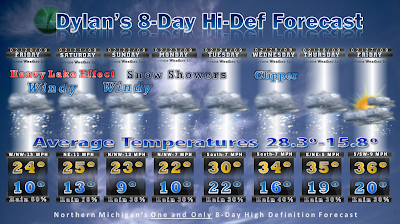
Now after we get all done with that we will have a little break and then here comes another system. Now its only a clipper system but will bring some snow about 3-6"inches and have some winds with it, but not to bad.
But now we are looking at another storm system that will impact the area. I am thinking that this one will affect the are on Sunday night into Monday. It looks like this one could be a pretty big storm! Now i do not have the snow fall forecast for that..It's only 8 Day's AWAY ;)
So that is the weather look for right now
Have Fun In The Sun!
Dylan Rodenbaugh
Junior Meteorologist
It Looks like the weather pattern that has been messing with us bring storm after storm is going to continue for awhile..It looks like every three days we have another system..

So Now Onto the next system. It looks like we are going to see a huge system go through the southern states (Texas) and ride up to the north.(through Kentucky) and head up our way. It looks as of right now that the storm is going to bring all snow..Over a 36 Hour Period somewhere between 8-24" Inches.. But No Surprise that the forecast models are not in agreement on where this thing is going. There is a possibility that we could see a mix/ice if it gets really far west. Or if it moves Forecast then we could have less snow.
Now this system is going to be different than a lot of the other storms. We aren't going to just see a ton of heavy snow overnight and then its gone. NO. This system will be here for 36 hours and cause a lot of problems..Because it wont stop.
So after we get done with that storm it looks like a break for a while. Till Friday :);) It looks like another clipper system will come through..IT will be a little heavier than a regular system. I'm expecting about 5-8" inches of snow.
After that It looks like another possible Monster snow storm for Monday Into Tuesday and Through Until Tuesday Night.. This one could also be quite a mess.
P.S I got the site up and its gong great...its http://www.dylansweather.com/
So there is your Gloomy Forecast...Enjoy
Dylan Rodenbaugh
Junior Meteorologist
Video Is A little slow with the audio its the graphics
OK So The Ice didn't turn out the way that as I thought it would. We got and early ice event and not as bad as it could have been. It looks like the temperatures are going to be climbing through the day and should reach the 30's. Then drop like a rock. It looks like 12 degrees should be the temperature by 8A.M. That would make any water on the roads frozen causing problems
Ok So Here Is My Forecast For This Week..It is a little dark..Thats Just The Lighting and I'm trying To Fix It..
Video Forecast 1-3-09 from Dylan Rodenbaugh on Vimeo.
For nearly twenty years, Meteorologist Dave Barrons has been a staple in northern Michigan, providing 9 and 10 News viewers with the latest forecast.Dave has meant a great deal the viewers and to his 9 and 10 News family.Dave Barrons has decided to retire and as we wish him luck we've included many of the memorable moments he's given us for the past 18 years.


